So, what do hikers talk about when on the trail? Mostly, conversations revolve around topics of immediate concern:
Terrain: “Dude, did you think that hill was ever gonna end?”
Resupply: “Are you going into town? I heard there’s an all you can eat pizza place just a mile off the trail!”
Weather: “Are we supposed to get any sun this week?”
Gear: “Is that a Zpack? How do you like it?”
Occasionally, a hiker shares a narrow escape or harrowing experience: “So there I was, soaking wet and freezing, trying to put up my hammock. Only I was so cold, my thumb and fingers wouldn’t work. I couldn’t grasp the ropes to tie the knots! I had to use my whole arm, and my teeth, to loop the rope around the tree! When I finally got the hammock up, I just crawled into it and shivered.”
Sometimes, a nugget of conversation turns out to be a gem. While eating breakfast at Wilson Creek Shelter, we enjoyed speaking with a section hiker named Sunshine. She told us, “I’m getting off the trail today. My son is getting married, and the shower for his fiancée is Saturday. I’ve got to get a pedicure before then! Wonder if they’ll be able to get all the duct tape off my toes?”
Candles tells Sunny and Jay of his brush with hypothermia.
“What’s it like?” my friend, Linda, asks. “You just walk all day, stopping to eat and talk to other hikers? What is your life, now?”
Well … yes … we just walk all day. And yet, every day is different. Come join me for a morning to see…
You will drive to VA Rt 630, parking at a small turn off when you see the AT white blazes. We are camped very near, so hike on in and join us as we pack our gear.
The first stop is just a half mile uphill, the Keffer Oak, the largest white oak tree on the southern AT, over 18 feet in circumference and over 300 years old. We stop to eat breakfast and admire this incredible tree. Lower branches sweep down, touching the ground dozens of yards away from the trunk. The crown of the tree towers over its surrounding neighbors. It is a truly impressive landmark!
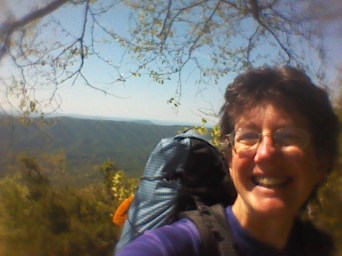
Jay next to the Keffer Oak.
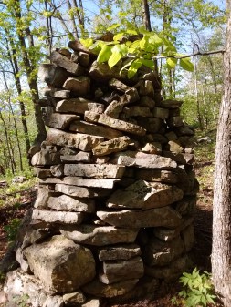
The trail continues, across a small field of tall grass, soaking our legs with early morning dew. As we enter the trees on the other side of the field, our path begins ascending Sinking Creek Mountain, a steep 1,100 foot, two mile climb. Ninety minutes later, the crest of the ridge brings us to a very wide, open, flat promontory with a cooling breeze to reward our efforts! Piles of flat, brick-sized rocks stacked neatly in circular piles, ranging from three to six feet in height, dot the top of the ridge. What could they be for? Do they mark a boundary of some kind? Obviously man-made, they are a mystery! The rock piles have old apple trees growing between. Hmmm, is there a connection? Perhaps this summit was farmed at one time? My mind boggles at the thought of the amount of sheer physical work it took to clear and stack all these rocks, and plant a mountain top orchard. I feel very small, just strolling along on this wide, level path, past evidence of the back-breaking struggle of early settlers!
Man made piles of rocks. What was the motivation?
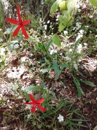
Flowers accent our walk. Lily of the valley leaves are common, but the beautiful white bells are unusual enough to be notable. Mayapples make small patches of green, with white and yellow blooms nodding underneath their canopies. Unknown tiny white flowers, dotted with purple wild geraniums and scarlet fire pinks, create small banks of color.
Unknown white flowers and fire pinks.
The trail continues to climb gently. I have been hearing the explosive rustle of squirrels deep in the undergrowth as they leap from tree to leaf-covered ground and back to another tree. Now, as the ridge begins to narrow, I start to see them, and they put on quite a show. One squirrel, gripping a fat acorn in his mouth, runs up a tree trunk, leaps to a leaning limb, misses his grip and slips, hanging upside down for a moment, then scrambles around, continuing upward. Another squirrel bursts out of a bush, bounds over a log, and hurtles toward a vertical tree trunk, landing with an audible whump, spread-eagle, claws digging into the bark. I watch as he visibly inhales, then clambers upward.
With the spine of the ridge narrowing, the trail follows along the western side of the mountain, stony slabs rising on top. Suddenly, our path makes a ninety-degree right turn and disappears through a keyhole-shaped breach between two boulders. We climb through, only to see … the other side of the mountain! This was so much fun for the trail builders, they do it several times, switching from one side of the ridge to another!
What do we see? Merely the other side of the mountain! But, oh, what fun!
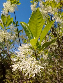
Just as legs are wondering if the trail will ever stop climbing, the trees open up, and there is a long, sweeping, rocky spine ahead. For the first time, I realize that Sinking Creek Mountain is a geological anomaly. Later, the internet tells me about the Pleistocene Ice Age, when enormous slabs of rock, up to 1.5 square miles in size, slid off the eastern side of this mountain, creating some of the largest known landslides in the world. But for now, it is a happy scramble along bare rock, with sun beating down, cliffs dropping off, and more wonder than my soul can hold! Blackberry vines curl over the edges of the ridge top. An unknown flowering shrub flaunts large gobbets of white flowers. Butterflies with wings of iridescent blue, black, and silver flit across the path. A rufous-sided towhee calls out, and I stop, looking into the ridge-side tangle of greenery for his red sides and black back.
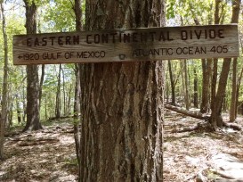
After a lovely scrabble over and around boulders and rock slabs, the northern end of the mountain ridge comes into sight. A sign announces that this is the Eastern Continental Divide, with the Atlantic Ocean 405 miles to the east, the Gulf of Mexico 1,920 miles to the west. Once again, I am overwhelmed with wonder. To be told that I am standing upon the dividing line between two such awesome bodies of water! This is an incredible world in which we live!
Here the trail drops off the ridge, taking switch backs through the trees and steep terrain. Down we go, down, down, down. Just as my knees begin to protest, Niday Shelter comes into view! Oh hurray! We have hiked for nine miles, and it’s time to stop for a late lunch!
Several thru-hikers have the same idea, and we spend a pleasant 45 minutes introducing ourselves to new hikers, chatting about the trail, other hikers, weather. Shelters along the AT are good places to meet others, as people stop to use the picnic table, privy, or even the shelter itself. Today, with sun beating down, we enjoy the shade of trees and the birdsong which punctuates our conversations.
Two miles further downhill, we come upon VA Rt. 621. It’s time for you to leave me, returning to civilization with the help of a pre-arranged shuttle. As a thru hiker, however, I’ve got several more hours of daylight, and a few more miles to hike. The top of Brush Mountain is my goal for the day. But, hey, since you are leaving this land of natural wonder, and returning to a more sophisticated life style, could you take my garbage with you?
My sister informs me that I need to let friends know “the end of the story” of my collarbone.
“Oh no,” I protest. “Surely everyone is sick of reading about that broken bone.”
My sister’s voice takes on a patient tone. “People want to be reassured. Are you truly all the way healed? What’s happening with you?”
So, I’ve decided to do a bit of housekeeping, letting friends know what’s up in my life, and answering “behind the scenes” type questions about hiking the AT.
1. Clavicle – I broke it six weeks ago. Spent two weeks camping near the Dismal Swamp of North Carolina during the most fragile part of healing. Then spent two weeks hiking in a sling, going slowly, grateful for Jay’s help. Two weeks more of hiking without the sling, slowly regaining the use of my arm and shoulder. Today I gave the sling to Goodwill. Hurray! Just a normal hiker now!
I’ll be swinging from vines soon!
2. Food – We resupply every four days, whenever we come near a store. We don’t carry a stove, and we eat the same food three times per day, every hiking day. This simplifies our life tremendously! Other hikers do not eat like this. Many carry stoves, and most seek variety. However, being bored with our food has so far been impossible when hiking eight to ten hours per day. Hunger is the best sauce!
What do we eat? We eat a mostly paleo diet on the trail. Sardines packed in olive oil, extra sharp cheddar cheese, dark chocolate, cashews or pumpkin seeds, and raisins. We also sometimes carry one unusual item for a leg of the trip. One week it was toasted coconut from my parents. Once it was a bag of figs and dates from a hiker box. A small bottle of home-made molasses from our friends, Alan and Mary, lasted five days. Yum!
Sardines, raisins, cheese, dark chocolate, pumpkin seeds, and one spoon! The ultimate hiking diet and utensil! (This is enough food for one person for three days.)
3. Sleep – The Appalachian Trail has shelters about every eight miles. These three-sided structures are used by many hikers. We prefer the comfort of our tent, which is bug-free, rain proof, and private. Every 100 miles, we stop in a town and stay at a hotel or a hiker hostel, doing laundry, getting a shower, and sleeping in a real bed. Ahhh!
Home sweet home!
4. Shoes – We hike in zero drop trail shoes, light weight and with no built up heel. Our old shoes have now hiked nearly 700 miles of the AT, and more than 400 miles in Nevada. They are done for! Hurray for new shoes!
Trent’s Grocery is a half mile down a busy road from the Appalachian Trail. It offers food for hiker resupply, and a grill with hamburgers, hotdogs, french fries. A very tempting detour!
Our adventure properly began as we reached the road, to find an older white-bearded hiker named BR sitting on the ground, a younger hiker, Trapper, hovering nearby asking, “Are you okay?”
We watched as BR used a pocket knife to dig an inch long splinter out of his arm. “Wow!” Trapper was impressed. “You should keep that as a souvenir!”
“Nah, it’s already gone!” BR growled as he tossed the splinter into the undergrowth and rubbed the blood across his arm.
“Would you like an antiseptic wipe?” I offered helpfully.
BR looked at me suspiciously from under lowered brows. “That sounds way too girly to me!” he snorted.
“It’s easy to reach!” I protested. “I could get it quick!”
“Look,” BR told me, “I’m French, I’m stubborn, and (he shouldered his pack and roared to the sky), we’ve got CHEESEBURGERS to eat! LET’S GO!”
The walk to the grocery was accomplished without incident, and we enjoyed our double bacon cheeseburgers with fries. While we ate, we listened to two young hikers, Firestarter and Trapper, as they discussed staying at the next shelter, Wapiti, which was supposed to be haunted due to a double murder that took place in 1981. Privately, I was glad Jay and I had no plans to stay there.
As we were leaving the grocery, a local man named Chris Miller began talking to Jay. “Want to know a shortcut?” he asked.
“Sure!” Jay responded with a smile. “No reason to hike that busy road if we don’t need to!”
“Yeah, this other road ain’t busy,” Chris agreed. “You might see a horse and rider, or maybe a drunk driver. That’s it.”
“So how do we find this shortcut?” Jay asked as BR came up and joined us.
“Well,” Chris began waving his hands, “ya don’t want to go back up the way y’all came. The trail’s gonna take ya up that mountain, then back down it, and end up at Dismal Falls, same as this other way. See, what y’all got to do is turn the opposite way here, go over the bridge, turn right on the road just past the bridge. No, not that one,” Chris pointed at the nearest road. “You need the road across the bridge. Ya can’t quite see it from here, but it’s right over there.” Chris gestured again. “Once you turn on the road, y’all will see a sign that says Dismal Falls – 1 mile. Now, keep in mind, it’s a mile up the road. You’ll pass my mother’s house…”
“We’ll wave to her,” Jay interjected.
“Naw, no use in doing that, she’s not home today,” Chris shook his head. “Okay, the road’s gonna bear left a bit, then take a sharp right turn. You’ll hear the falls by then. Look right, down the slope, you’ll see a log.” Chris paused. “It’s okay, we just put it there 10 years ago. It’s a little shaky, but it’ll hold ya.”
“We’ll let her go first,” Jay joked, gesturing to me.
Chris turned and grinned at me. “They gonna guinea pig yore ass! Anyway, ya cross the log, then you’ll see blue blazes leading y’all right back to the AT. It’s easy!”
We made Chris repeat the directions at least two more times, trying to get all the lefts, rights, and logs in the correct order. Then we looked at each other and Jay spoke for us all. “It’s an adventure! Let’s do it!”
After we had been walking about 15 minutes, we met a hiker. “Oh good!” I thought. “We’ll get real hiker directions, not just directions from someone who probably only drives this route.”
The hiker, named Gelfling, was not reassuring. “I don’t know why he told you to cross a log. You’ll have to wade to reach the log! And that water is COLD! I just waded it to get over here. Of course, you could keep on this road for another three miles, where it crosses the AT again.”
BR was indignant. “What kind of shortcut are we on? That guy never said anything about wading!
We continued on, hoping to solve the mystery and get reunited with the AT, preferably without getting wet. Another 15 minutes brought us to a small parking area and a sign, announcing Dismal Falls. We turned and followed the path to the bottom of the falls. Chris Miller was right, the thunder of the falls could be heard a goodly ways away!
Jay and BR saw the log which reached halfway across the stream, and began discussing Gelfling’s directions compared to Chris Miller’s. I looked to the top of the falls and saw another log laying across the whole stream, just 50 yards above the falls. “Hey, there’s the log we need!” I exclaimed.
We returned to the road and rounded a sharp turn to the right, with BR grumbling still over directions. “He could have said the log after the parking area and sign!”
The log, when reached, turned out to be about 75 feet long, and only a few inches above a very swift, waist deep stream. I went first, confident with a large, stable, flat tree to walk upon. As I progressed, the log gradually narrowed and began bouncing. The surface of the tree became eroded, ridged and bumpy. Rushing water played havoc with my eyes, making it hard to balance. I stopped, suddenly terrified. My fear was not allayed as I heard, just behind me, Jay asking, “Why are you stopping?” Far behind, I could hear BR shouting, “You’re not helping, being right behind her! You’re making it bounce more!” Slowly, I resumed forward progress, carefully feeling each inch. The tree continued to narrow as the far shore steadily approached. My nerve broke, and I ran the last few steps, just wanting to be OFF! Whooeee! What an adrenaline rush!
By the time all three of us had crossed, we were chattering like schoolchildren. We had made it, and, just as Chris Miller had promised, there were the blue blazes leading right back to the AT. Whether our route actually turned out to be shorter or not was debatable. As BR said, “That was fun, but I wouldn’t do it again!”
Today, once again the trail followed ridge tops, this time with very little water available. After hiking nine miles, we came to the turn off for Helveys Mill Shelter. Our water bottles were empty. The trail guide said the shelter was three tenths mile away, with water a further three tenths mile. If we turned to get water here, we would be adding 1.2 miles to our day. But the next water according to the trail guide was seven miles away! We only had enough daylight to walk about three more miles. It seemed a shame to waste one mile on getting water!
“Surely,” we thought, “with all the recent rain we’ve had, there will be a small unmarked streamlet closer to the trail!” We knew it was a gamble, but couldn’t resist the adventure of trying! “After all,” I told Jay, ” the worst that could happen is we spend a night thirsty, before we find water tomorrow.” We continued, the excitement of the gamble giving spring to our steps!
Soon we met a woman hiking southbound. “Oh boy,” I thought. “She’ll know if there is any water near.” We talked with her a few minutes, but she only had disheartening news. “It’s dry, dry, dry for the next several miles,” she told us. “Plus there’s bear sign (poop) several places down the trail! You’d be better off turning around and going to that shelter!”
Though we acknowledged that she was giving good advice, we felt set upon our course, and, wishing each other happy trails, we continued north, while she continued south.
Ten minutes later, we met another southbound hiker! He told of seeing, two miles further, a sign written with rocks on the trail saying “H20” with an arrow. “I looked down the slope, but didn’t see any water. Perhaps if you went far enough, you might find some,” he told us.
Again we continued, but now buoyed in hope for ending our day’s hike with a cool drink. In due course we found the sign and happily turned off the trail. A flat, sheltered spot invited us to stop and pitch the tent. Beyond, two small slopes met, beginning a dry waterway that could, possibly lead to water…
I followed that dry stream bed all the way to the bottom of the ravine, looking for liquid. The slope quickly steepened, until I could reach out with one hand and touch the ground without stooping! When describing it to Jay later, he suggested, “It was so steep, you couldn’t tell whether you were standing up or laying down!” Yes, exactly!
At the bottom, the arid waterway joined … another dry creek bed. I stood at the confluence with my empty water bottles, shoulders sagging, twigs sticking in my hair, leaves clinging to my socks, totally disappointed and thirsty. Then, suddenly, I realized I could hear water! I looked up the new ravine, and there about 50 yards uphill, a stream had surfaced for 10 feet or so! Happily, I filled my water bottles, then walked/crawled back up the mountain side to where Jay had the tent all set up. Hurray! With a bit of luck and persistence, our gamble had paid off!
Seems like we’ve had days and days of gray skies and water. Today was supposed to be sunny. We woke to see the valley below our ridge top completely filled with clouds. By the time morning chores were completed, the clouds had risen, enclosing us in wet, clingy fog. We hiked with clouds touching us, or hovering just above us all day long. Sometimes it sprinkled, mostly it didn’t. I tried thinking positively – no bugs! no need for sunscreen! no sweat going uphill! Jay was better at sounding truly happy when he told other hiker all those things. But at 4:00, when the sun shone for exactly two minutes, I cheered! There were still dark clouds hovering just off the edge of our ridge, but even fleeting sunshine brought hope of more!
We hiked along a ridge top much of the day, only dipping off it every few miles for a brief visit to a spring for water. Nearby trees and gray clouds were the sum total of our view. For a few miles the trail dropped down to cross rolling fields and climb fence stiles. One long swampy area boasted board walks through watery plants. Fun!
Today’s highlight was a conversation we had with Cashew, a hiker in his twenties. We last saw him on Saturday, as we left the trail together, but went to different hostels. Today we re-met as we stopped at a spring for water.
“Oh, how was your hostel?” I asked.
“It was very new. The owners were still getting it set up. Everyone was very nice. They’re building a pavilion for people who want to sleep in hammocks but still be under a roof.”, Cashew told us.
“A pavilion just for hammockers!” Jay exclaimed. “That sounds like segregation to me! If they’re going to make a special place just for hammocks, they should build something for tenters, also! Equal rights and all that!”
Cashew was a bit startled by this viewpoint, but answered Jay gravely, “I guess hammocks take up less room, a pavilion for them might make sense.”
“Oh, well,” Jay’s imagination had only begun. “If they’re worried about room, they could stack the hammocks one on top of another. Perhaps bear cables could be used, to move the hammocks up and down. Of course, one would want to be careful of who ended up on the bottom at bed time, otherwise everyone would be going up and down all night as people answered nature’s calls.”
Between Jay’s flights of fancy and Cashew’s expressions as he tried to decide whether Jay was serious or not, I was laughing hysterically! Nothing like a bit of silly added to a day of hiking!
Hiking while healing a broken bone is no joke. It takes a great deal of energy to hike in the Appalachian Mountains, and it takes a great deal of energy to heal a bone.
Here are a few things to keep in mind when starting to hike with a cracked collarbone:
First, spend two weeks recuperating in a quiet place.
Second, find a hiking companion who will carry your food and community gear. The term, ‘sherpa’, may or may not come up in the negotiations. If you are lucky, the hiking companion is a much-loved husband (Jay) or wife or sister or brother or friend.
Third, find an engineer to redesign your pack with only one shoulder strap, preferably across your good shoulder. Jay took the straps on my ArcHaul Zpack and rigged a y-shaped harness holding the pack onto my back.
Fourth, wear a really good sling. I’m very grateful to my doctor for insisting upon an excellent sling for my arm.
Fifth, listen to your body. The third week of healing, and simultaneously, the first week back hiking the AT, we only walked about eight miles a day. I knew it was time to stop when the fire and brimstone would start glowing inside my broken bone, usually sometime during the last mile of each day.
Sixth, walk slowly, stopping often to admire the scenery. Walk slowly, stopping often to talk to your sherpa, um, I mean loved hiking companion. Walk slowly, stopping often to just sit and rest. Walk slowly.
Finally, try not to gag when people on the trail say, “Oh, you’re so brave to be still out here hiking!” I am not brave. Bravery and courage happen when one takes action even though the action scares one silly. Although there are scary situations on the AT, especially regarding weather, I do not see hiking with a half-healed clavicle as scary. Perhaps I just have an astonishing lack of imagination. So what adjectives describe hiking while healing? Persistent – possibly. Pig-headed – probably. Set upon one course – certainly. Obstinate – obviously. But the adjective I like best was given by a local man walking his dog today. “You are one determined woman!” Yes, determined – definitely!
P.S. At all times, maintain a sense of humor!
Houdini and Cashew make an arch of trekking poles as I process down the trail!
A night of rain and storm found us snug inside our tent, dry and warm while water fell from the sky. We woke early, packing up as sunrise brought possibilities of dryer weather.
Scattered cloud bits lingered over the landscape. I remembered two days ago, waking to a dense fog. “We’re getting kissed by a cloud,” Jay had joked. I had eyed the grey clinging tendrils of moisture, and replied, “Seems more like an overly enthusiastic embrace to me!” Today, the white puffs did look a bit more like gentle kisses from the clouds.
Laurel Forks Gorge and Pond Mountain Flats were the major destinations on the map today. For a while the trail was almost level as it followed an old railroad grade, hugging cliff top edges, cutting through narrow gaps between ridges, teasing us with glimpses of Laurel Fork far, far below. Finally, the trail made a sharp left turn and dove over the edge, switchbacking steeply down turn after turn of stone steps, spiraling deeper and deeper into the gorge. At the bottom, water rushed over wide rock ledges, in a jumble of froth and foam, dropping 45 feet into the quintessential pool at the bottom. What a destination for the morning!
The trail followed the river, sometimes edging out on tiny ledges inches above the rushing water, but mostly on a wide level path, just right for a Sunday stroll.
Walking the ledges with one arm in a sling. Total fun!
We met Specs, a very nice thru-hiker in his twenties. He told us of staying the rainy night at a hostel in a man’s house. “There were bunks for about 20 people, but only 5 of us were there. When it began raining, I discovered that his roof leaked, so I had to hop over to another bunk in my sleeping bag!”
Specs also told us that he met the man in charge of trail maintenance on this portion of the AT. “This guy told me that the trail used to go straight up Pond Mountain Flats, but now there are 15 switch backs and an extra two miles of trail to get to the top.”
“I’m not sure that I really wanted to know that,” Jay informed Specs.
“Fifteen switchbacks! I love switchbacks! Oh goody!” I exclaimed happily. “Let’s do it!”
Fifteen switchbacks and 1,800 feet of elevation did give me plenty of time to wonder about the name of the mountain we were climbing. Would it really be flat? What kind of mountain had a pond on top? So far on this trip, mountain tops had sported dry ridges, rocky ledges, sometimes rolling grassy balds. But I had yet to see much water on a mountain peak, other than the water I carried to drink!
At the top, the terrain did flatten out a bit, with a couple of campfire rings and tent sites. We paused for a look around. No pond, no water, but wait, what was that? A frog, hopping through the leaves! He stopped and posed for Jay’s camera. “There must be water somewhere, with this frog hopping about,” Jay remarked. “The trail guide says there’s a spring in half a mile. Let’s go fill up, and maybe eat lunch.”
Mountain top frog!
Just as we reached the spring, a rumble of thunder caused us to look up. Black and grey piles of moisture loomed over the mountain. “Yikes! Is that headed here?” I asked nervously. “Maybe we better postpone lunch until we’re a bit lower in altitude,” Jay suggested.
Just then a ball of lightning FLASHED ahead of us. My scream was drowned by a simultaneous BOOM of thunder. I turned and flew into Jay’s arms! “Umm, let’s go while we can,” Jay suggested. “But be careful! No falling allowed!”
Rain pelted our heads as we warily slogged down hill. Thunder and lightning crashed. Wind blew through tree tops and whistled over ridge edges. Just as I was set to endure hours of storm, it stopped! The rain slowed to a pitter-patter, then ceased altogether as the sun appeared. “Wow!” Jay laughed. “Would you call that a cloud kiss, or something else?” I knew what he was thinking, but answered primly, through giggles, “In my day, that was called a cloud burst!”
I guess that frog knew there would be water on top of the mountain after all!
While recuperating from my broken collarbone at Merchant’s Millpond State Park, Jay and I met a couple from Quebec. Robert and Liliana were camping from the back of a motorcycle, a feat which aroused my admiration. They, in turn, were intrigued with our goal of walking 2,000 miles from Georgia to Maine. We enjoyed a morning of conversation, with a smattering of French, lots of slowly spoken English, and a great deal of mime to help bridge the language challenge.
At one point our talk touched upon my broken collarbone, and my determination to continue hiking. Robert told me, “I don’t know the English words, but we say there is a fine line between ‘acharnement’ and ‘entetement’.”
That sparked a lively discussion as we endeavored to puzzle out the English equivalents. For ‘acharnement’, Robert came up with the cognate, ‘perseverance’, which led Jay to contribute the word ‘persistence’. As we wrestled with the word ‘entetement’, Jay and Robert thought perhaps the word ‘stubborn’ might be the translation, but was there a better word? Liliana and I looked at each other, and spoke on the same breath, “Pig-headed!” “Tete de cochon,” Liliana added, laughing.
That conversation has stuck with me these past nine days as I hiked with my arm in a sling and only one usable shoulder strap on my pack. In order to finish 2,000+ miles in one hiker season, one MUST be persistent. But when does persistence change to pig-headed stubbornness? Many of my family and friends think I am risking too much by hiking after only two weeks of recuperation. And yet, I am following the collective knowledge of our years of hiking experience, and the wisdom of our doctor. (“Do I think you will spend the next weeks doing nothing? Not in a million years! Just limit your mobility, add activities slowly, the way I’ve shown you, and DON’T FALL!”)
Jay and I have hiked 85 miles in the past nine days, dawdling at viewpoints, ambling through flower-strewn forest, picking and eating ramps (a wild-growing Appalachian delicacy), and just taking our time. Daily my collarbone and shoulder have hurt less and become more mobile. It has been exciting to feel it healing while experiencing the beauty of spring and know I am still making small progress upon my self-imposed goal of hiking the AT.
So, to all my friends and family who have told me, “Be careful, be safe, take care, don’t risk,”… thank you from the bottom of my heart for your concern and love. I feel very lucky to have such caring people around me! However, I think of my last words with Liliana, and I know, “It’s time to CHOOSE LIFE!”
Three weeks ago, when I broke my collarbone, Winter was still in charge of the forest, with Spring shyly peeping between the trees, barely showing the hem of her petticoat. When we returned to the mountains, Spring had taken center stage, kicking up her heels, showing flounces, ruffles, and lace in a wild display of joyous life!
The brown leaf covering of the forest floor is transformed into a carpet of glowing, vibrant GREEN! Mayapples unfurl their umbrellas. Twin bunny-ear-shaped ramps poke above spotted trout lily leaves. Heart-shaped violet leaves give way to compound shaggy Dutchman’s breeches. And everywhere, the small narrow lance-like leaf blades of spring beauties fill in the background.
That emerald backdrop is the canvas for some truly beautiful blooms. Yellow-white Dutchman’s breeches hang from slender stems, like laundry out to dry. Pink-striped white spring beauties cover the ground, imitating scattered snow flakes. Purple, yellow, and white violets lift painted faces to the sun, while yellow trout lilies hang their heads but curl their petals back in a shy invitation to the bees. Hugging the ground, tiny gaywings add spots of purple, and giant red trilliums nod above them all.
On our first day back on the trail, Jay and I were awed and enthralled. We stopped to rest on a fallen log, surrounded by acres, miles, of beauty, a cathedral of life. Jay spoke for us both. “I’m glad we didn’t miss this.”