May 16, 2017
“What’s it like?” my friend, Linda, asks. “You just walk all day, stopping to eat and talk to other hikers? What is your life, now?”
Well … yes … we just walk all day. And yet, every day is different. Come join me for a morning to see…
You will drive to VA Rt 630, parking at a small turn off when you see the AT white blazes. We are camped very near, so hike on in and join us as we pack our gear.
The first stop is just a half mile uphill, the Keffer Oak, the largest white oak tree on the southern AT, over 18 feet in circumference and over 300 years old. We stop to eat breakfast and admire this incredible tree. Lower branches sweep down, touching the ground dozens of yards away from the trunk. The crown of the tree towers over its surrounding neighbors. It is a truly impressive landmark!

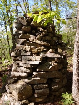
The trail continues, across a small field of tall grass, soaking our legs with early morning dew. As we enter the trees on the other side of the field, our path begins ascending Sinking Creek Mountain, a steep 1,100 foot, two mile climb. Ninety minutes later, the crest of the ridge brings us to a very wide, open, flat promontory with a cooling breeze to reward our efforts! Piles of flat, brick-sized rocks stacked neatly in circular piles, ranging from three to six feet in height, dot the top of the ridge. What could they be for? Do they mark a boundary of some kind? Obviously man-made, they are a mystery! The rock piles have old apple trees growing between. Hmmm, is there a connection? Perhaps this summit was farmed at one time? My mind boggles at the thought of the amount of sheer physical work it took to clear and stack all these rocks, and plant a mountain top orchard. I feel very small, just strolling along on this wide, level path, past evidence of the back-breaking struggle of early settlers!
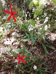
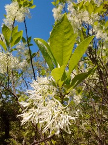
Flowers accent our walk. Lily of the valley leaves are common, but the beautiful white bells are unusual enough to be notable. Mayapples make small patches of green, with white and yellow blooms nodding underneath their canopies. Unknown tiny white flowers, dotted with purple wild geraniums and scarlet fire pinks, create small banks of color.
The trail continues to climb gently. I have been hearing the explosive rustle of squirrels deep in the undergrowth as they leap from tree to leaf-covered ground and back to another tree. Now, as the ridge begins to narrow, I start to see them, and they put on quite a show. One squirrel, gripping a fat acorn in his mouth, runs up a tree trunk, leaps to a leaning limb, misses his grip and slips, hanging upside down for a moment, then scrambles around, continuing upward. Another squirrel bursts out of a bush, bounds over a log, and hurtles toward a vertical tree trunk, landing with an audible whump, spread-eagle, claws digging into the bark. I watch as he visibly inhales, then clambers upward.
With the spine of the ridge narrowing, the trail follows along the western side of the mountain, stony slabs rising on top. Suddenly, our path makes a ninety-degree right turn and disappears through a keyhole-shaped breach between two boulders. We climb through, only to see … the other side of the mountain! This was so much fun for the trail builders, they do it several times, switching from one side of the ridge to another!
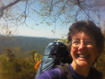
Just as legs are wondering if the trail will ever stop climbing, the trees open up, and there is a long, sweeping, rocky spine ahead. For the first time, I realize that Sinking Creek Mountain is a geological anomaly. Later, the internet tells me about the Pleistocene Ice Age, when enormous slabs of rock, up to 1.5 square miles in size, slid off the eastern side of this mountain, creating some of the largest known landslides in the world. But for now, it is a happy scramble along bare rock, with sun beating down, cliffs dropping off, and more wonder than my soul can hold! Blackberry vines curl over the edges of the ridge top. An unknown flowering shrub flaunts large gobbets of white flowers. Butterflies with wings of iridescent blue, black, and silver flit across the path. A rufous-sided towhee calls out, and I stop, looking into the ridge-side tangle of greenery for his red sides and black back.
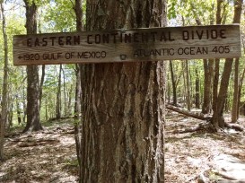
After a lovely scrabble over and around boulders and rock slabs, the northern end of the mountain ridge comes into sight. A sign announces that this is the Eastern Continental Divide, with the Atlantic Ocean 405 miles to the east, the Gulf of Mexico 1,920 miles to the west. Once again, I am overwhelmed with wonder. To be told that I am standing upon the dividing line between two such awesome bodies of water! This is an incredible world in which we live!
Here the trail drops off the ridge, taking switch backs through the trees and steep terrain. Down we go, down, down, down. Just as my knees begin to protest, Niday Shelter comes into view! Oh hurray! We have hiked for nine miles, and it’s time to stop for a late lunch!
Several thru-hikers have the same idea, and we spend a pleasant 45 minutes introducing ourselves to new hikers, chatting about the trail, other hikers, weather. Shelters along the AT are good places to meet others, as people stop to use the picnic table, privy, or even the shelter itself. Today, with sun beating down, we enjoy the shade of trees and the birdsong which punctuates our conversations.
Two miles further downhill, we come upon VA Rt. 621. It’s time for you to leave me, returning to civilization with the help of a pre-arranged shuttle. As a thru hiker, however, I’ve got several more hours of daylight, and a few more miles to hike. The top of Brush Mountain is my goal for the day. But, hey, since you are leaving this land of natural wonder, and returning to a more sophisticated life style, could you take my garbage with you?

Great writing, answering many questions. I’m almost finished reading “Lost on the Appalachian Trail” by Kyle Rohrig. I know you can’t write & post every day. Could you possibly write something like, “On May 21 (whatever date you choose) we stopped for the night (or day) at…” and give a town or place or location name on the trail? I have an AT map and would love to be able to see where you are at times. Do you have trail names and have you encountered trail magic?
LikeLike
Jay has been keeping a page titled Mileage. That will tell you where we stay each night. He updates it about once every 100 miles. We also have a page titled Trail Angels where we log particularly special encounters and trail magic.
LikeLike
Beautiful! Love the description, and I FEEL like I’m there with you. Beautiful photos, too. Love you!
LikeLike
I liked hiking Sinking Creek Mtn even more than McAfee’s Knob! I’m glad you liked it, too!
LikeLike
Thank you for taking me along. I live in Virginia and do day and weekend hikes along the AT often. However, this summer I am away from home on extended work trips and missing the mountains a lot. I am hoping to get up there on the July 4th holiday weekend for some hiking and trail magic. This would be around Waynesboro near the crossing at Reeds Gap.
LikeLike
We just came through Reed’s Gap! We’re in Waynesboro VA, taking a rest day today. There is some incredibly beautiful trails here, and some very friendly people!
LikeLiked by 1 person